Saturday, November 26, 2011

ISOLATION

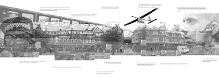
In a society where we have become the panopticon, where we are recording our every interaction, all trust has been lost. People no longer feel that their secrets will be kept, that their stories will stay sacred and that their lives will stay their own. Combined with technology that reduces human interaction through every day tasks, physical and eye contact become an invasion of privacy, people have become faceless shapes and the built environment has become an empty outline. We have become isolated.


I AM NOT A NUMBER...


PROJECT 2.2 FIRST DRAFT


THE PANOPITCON

Playing with the idea of surveillance, one of the references that I was given was Jeremy Bentham's Panopticon.  A concept where the warden in the tower can look into the surrounding cells without being seen, creating an unknown for the inmate on whether they are being watched or not.


WALKER AND GOOGLER ROUTES

I decided to analyse the site through the walker and the googler, taking into consideration the areas that the googler cannot see.

The Googler

The Walker

SITE AND SURROUNDING AREA

The following sheets analyse the area of surrounding the Spitalfields and Banglatown area, through a number of photographs.  The third image analyses the wider area in terms of the intensity in the number of cctv cameras in the area.  As you progress east across the area, the number of cameras decrease, along with the standard of living. 

Wednesday, November 16, 2011

GOOGLE MAPS LIVE 2020???

Taking into account the development of surveillance in the city by 2020, Google Maps is now a program that is able to run a live-feed.  This allows the Googler to view the area within 'real-time'. Although they are still being presented with a digital image and digital mapping of the area, they are now seeing what happens in that space at the exact time it occurs, which essentially includes the vector of time.  Will the boundaries of digital and 'real' mapping of our cities always be so blurred? Will there be any point in the future where there is a direct and obvious moment when the digital becomes the real or the real becomes the digital?


Tuesday, November 15, 2011

SPITALFIELDS 2020

The collage below is beginning to show the technology that will be used in the city of London. This varies from the use of unmanned aerial vehicles capturing live footage, cameras situated at eye-level height in order for easier face recognition and also chips and ID tags for every individual.  With the advancements of technology, the city is essentially becoming a 'Big Brother' society where every movement and moment of your day is traced, captured and recorded.


TECHNOLOGY TIMELINE

I decided to create a time-line looking at the development of surveillance, the internet and also Google Maps as I believe that as they continue to develop they will have an unbelievably strong impact on the way in which we view and interact with the city, more so than today.


SPITALFIELDS MARKET TIMELINE

Here is the second time-line, illustrating the key points associated with the history Spitalfields Market.


Image Credits (Left to Right)
http://photos.casebook.org/displayimage.php?album=20&pos=6
http://photos.casebook.org/displayimage.php?album=20&pos=7
http://123bethnalgreenroad.blogspot.com/
http://brianhuman.co.uk/wp/2011/01/spitalfields-revisited/
http://www.flickr.com/photos/bettsy1970/287195876/in/photostream
http://www.fotolibra.com
http://lycos.londontown.com
http://www.jesticowhiles.com/news-info.php?n=120
http://www.e-luminate.co.uk/case-studies/

BRICK LANE TIMELINE

As part of my development and site analysis for both my project and dissertation, I have created a number of time-lines as a way of analysing the history of the area. The first time-line I've created is of Brick Lane.


Image Credits (Left to right)
http://www.vam.ac.uk/
http://www.tabletmag.com/page/21/?cat=13
http://www.vam.ac.uk/
http://anglo-swiss.blogspot.com/2007_08_12_archive.html
http://www.esplen.com/andrea/portfolio/dsa/history.htm
Synagogue photo: Rachel Lichtenstein
Jewish  © The Jewish Museum, London
http://www.san-miguel-de-salinas.com/uk/mickey.asp
Family Image http://www.swadhinata.org.uk
399px-A_different_world
http://www.fdin.org.uk

Sunday, November 13, 2011

PROJECT 2.1

Here's the second attempt at the project 2.1 where we had to outline our dissertation and project topic.  I want to focus on the idea of a digital city and the real city where De Certeau's 'walker' exists.


Monday, November 7, 2011

AFTER EFFECTS TEST - SPITALFIELDS MARKET

Here I've attempted to take the collage that I created for the 'walker' in Spitalfields Market and to transform it into a film using After Effects.


Sunday, November 6, 2011

SPITALFIELDS MARKET AS SEEN BY THE 'WALKER'

This next collage is trying to represent how the 'walker' experiences Spitalfields Market. 


Image Credits
Georgia Tsoulou                                                                                           http://www.lucas-smith.co.uk/photos/spitalfieldsmarket/
Gwynne Jones  http://www.mondoarc.com/projects/retail/228781/old_spitalfields_market_london_england.html
http://www.infobritain.co.uk/street_markets.htm
http://www.london-insider.co.uk/2010/01/spitalfields-market-a-winter-wonderland/
http://www.flickr.com/photos/dgeezer/2876578644/                                         http://www.eatingbritain.com/old-spitalfields-market-a-taste-of-the-eastof-london/ http://www.flickr.com/photos/stevecadman/4365434797/in/photostream

GOOGLE MAPS FILM

The film below explores how the viewer perceives Spitalfields Market through Google Maps and how the market may exist within the program. It aims to emphasise the restrictions of Google Maps as the inside area of the market is not visible.


PROJECT 2.1 TEST FILM

Here's the first attempt at the film for Project 2.1.


Saturday, November 5, 2011

NEXT IDEAS AND STEPS...

Google Maps presents us with a predetermined view of the city.  Whilst I wish to show this in a film I also also want to look at the view of the 'walker'.  


The 'walker' stems from Michel du Certeau's 'Spatial Stories' (found in the book "The Practice of Everyday Life") where "...the street geometrically defined by urban planning is transformed into a space by walkers".  


The 'walker' and the 'viewer' are both mapping Spitalfields Market through different means and the results of this can be very interesting.  The 'viewer' can only observe what the camera of Google Maps can see, which is fixed in position and time, whilst the 'walker' can experience what is hidden from the 'viewer'.


A 'walker' is free to walk and to look at what they wish, and according to du Certeau, because of the vectors which include time and direction, the 'walker' is changing their environment, something that the 'viewer' through Google Maps is unable to see and experience.  Whilst they are viewing a static and fixed architecture, and are unable to see into Spitalfields Market, in real time, the space might now be an aquarium, a football stadium or it may even cease to exist due to the 'stories' that all of the individual 'walkers' have placed upon the area. 


Another aspect that I was interested in was the loss of identity Google maps represents.  Whilst the 'walker' can see and interact with the built environment around them and also with the people, Google Map blurs out any people that are seen in the image and also many signs. Any thing that has a specific identity is simply blurred, emphasising a disconnection between the 'viewer' and the city.  Also, as the images of Google Maps do not represent real-time, it can be used as propaganda in a time when the area has declined.


I want to develop and analyse these points further, through more images and film.  

GOOGLE MAPS REPRESENTING THE CITY

The image below is attempting to map the camera of Google Maps and how the city is perceived as a 3 dimensional entity.  When analysing how the viewer is perceiving the space and the way in which Google Maps represents it, it becomes evident that it is a build up of layers and that whilst it represents depth and form it is actually a shell, and it represents only the surface of the built environment.

MAPPING GOOGLE MAPS

The image below is mapping the use of Google Maps when using it to view Spitalfields Market.  Each position of the camera is marked out along with the area of projection showing the restrictions of Google Maps.  The white area that is visible within the market is space that cannot be seen to the user of Google Maps.  One can therefore begin to question whether the space actually exists and if it does, without being able to see the size or use, one can make their own reality.


SPITALFIELDS MARKET THROUGH GOOGLE MAPS

Not living local to the site, my main point of contact to the area, in terms of mapping and viewing the built environment is through Google Maps.  The following collage represents how Spitalfields Market is perceived through Google Maps and essentially how the viewer perceives the building through a number of images.


TIME BASED COLLAGES

After presenting both my film on Wednesday and the collages as images pinned up in the wall, it became evident that the film was far more successful in portraying the idea that the areas develop over time.  I have therefore tried to portray time in the new drawings where it is visible to see the areas grow layer by layer.


Premiere Pro Issues

I've placed the collages in a film but Premiere is still running extremely slow at the moment. I will post the film as soon as I get it up and working again.